Finding Birds in Guilford County © 2018 Dennis Burnette
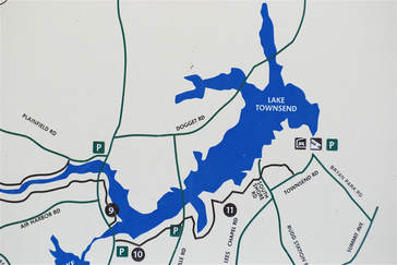
III-F. Birding Lake Townsend
Lake Townsend Marina
6332 Lake Townsend Rd, Browns Summit, NC 27214
336-373-3694
https://www.greensboro-nc.gov/departments/parks-recreation/the-lakes/lake-townsend
Administrator: Greensboro Parks & Recreation Department, 1001 Fourth Street, Greensboro, NC 27405, 336-373-2558
https://www.greensboro-nc.gov/departments/parks-recreation
Hours of operation: Currently, the marina is closed on Wednesdays and Thursdays. The marina opens at 8:00 a.m. November through February and 7:00 a.m. every other day except Sundays when it opens at 8:00 a.m. Closing times vary by season between 7:00 p.m. and 8:30 p.m. Check with the marina office for exact closing time. All Greensboro city lakes maintain normal operating hours during all holidays with the exception of Thanksgiving Day, Christmas Eve, Christmas Day and New Year's Day when the lakes are closed.
Directions
|
GPS coordinates (Lake Townsend Marina): N 36° 11.175’ W 079° 43.858’
Directions: Most Guilford County birders approach from the western end of the lake, checking the western overlooks as they skirt the lakeshore. This can be done either by going north on Yanceyville Street or south on Church Street. Another good alternative for the birder who is doing a birding tour of the lakes is to come from Lake Brandt Marina via Plainfield Road, which passes the Richardson-Taylor Preserve and crosses part of Plainfield Marsh, both of which are described elsewhere in this guide. If you choose to start at Lake Townsend Marina (see below for more details) on the eastern end of the lake, it may be reached by going north on US Hwy 29. About 8 miles north of I-40, watch for the signs directing motorists to Bryan Park. Exit US 29, and get on Summit Avenue, then go 0.7 mile south to Bryan Park Road. One reason for birding the marina first before proceeding would be to get an early morning start. The birder would be facing west across the length of the lake with the sun coming up from behind. |
When coming from Lake Brandt via Plainfield Road, birders have a choice. At the T-intersection one may turn left (north) and take Church Street 0.4 mile to the next intersection, Archergate Road. Turn right, drive 0.9 mile to Yanceyville Street, and turn right to get to the Yanceyville causeway or left to the Yanceyville Marsh and the Doggett Road overlooks (see below). Alternatively, one may turn right and stay on Church Street to check the overlooks. This is the route we’ll take in this guide.
Description
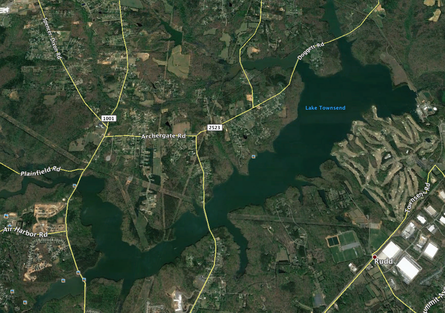
Lake Townsend is the largest of the City of Greensboro municipal reservoirs, comprising 1542 acres. It is also the newest of the three artificial lakes, having been open to the public since 1969. For information about hours, programs, and services, contact the marina directly at the phone number listed above. For watershed trails, go to https://www.greensboro-nc.gov/departments/parks-recreation/trails-greenways/hiking-trails or call 336-373-3816.
In addition to hosting a lot of anglers, Lake Townsend is very popular for pleasure boating, especially sailing, and is the home of a yacht club that sponsors sailing events in the summer. Weekdays have lower fishing and other human activity levels than weekends, so bird activity is commensurately higher. Fairly frequently there are interesting birds on the lake in late fall, winter, and early spring, as well as after strong storms with easterly winds.
Because of the size of the lake, there are seven good birding overlooks accessible by car described here. In addition to these spots, two trails follow the south shore of the lake, together forming a 7.5-mile hike through typical Piedmont hardwood forest overlooking the lake. Note that these are linear trails, not loop trails, so a birder will hike whatever distance is comfortable, then return by the same route. Common woodland birds may be seen or heard, as well as waterfowl and gulls on the lake. At several points the trails skirt secluded inlets that seem far from human habitation. The Osprey Trail (2.4 miles) begins on Church Street and ends on Yanceyville Road. The Townsend Trail (5.1 miles) begins on Yanceyville where the Osprey Trail ends and continues to Southshore Road, which is 0.3 mile from Townsend Road. Since these are not loop trails, some thought must be given to transportation at the end of the hike if you don’t want to retrace your steps.
Church Street Overlooks
If one comes from the city of Greensboro north on Church Street, the lake will soon be obvious. However, in this guide the directions are from Plainfield Road. Turn right (south) from the T-intersection at Plainfield Road on Church Street toward downtown, and the road will cross the western edge of Lake Townsend at two overlook points.
Stop 1. North Church Street Overlook (GPS Coordinates: N 36° 10.539’ W 079° 47.493')
Parking for this lake overlook has been reconfigured in recent years. At the intersection of Church Street and Plainfield Road will be signs directing motorist where to park. It is no longer possible to park at the trailhead of the Laurel Bluff Trail, which is just 0.2 mile south of the intersection. From the new parking area, a birder may view the lake looking east and part of the marsh by looking west. The trailhead is marked with a sign on the west side of the street. This is the east end of the Laurel Bluff Trail (3.5 miles), which will take a hiker through beautiful woodlands along the south shore of Reedy Fork Creek west to the Lake Brandt dam spillway near the Lake Brandt Marina. (Keep in mind that this isn’t a loop trail.) The trail is named for a laurel thicket through which it passes on a hill overlooking the creek, which gives the hiker the impression of being in the mountains rather than in the Piedmont. Typical woodland species of the upper Piedmont can be found along the trail, and occasionally there are ducks, as well as a few shorebirds during migration, in the shallows and mudflats of the creek.
From this parking area, one can walk a few yards to the bridge and scan both sides for waterfowl and wading birds. Looking west into the swollen Reedy Fork Creek, one sometimes can catch glimpses of ducks and wading birds if fishing boats haven’t entered the area, especially on weekdays when the marina is closed. On the other side look for Pied-billed Grebes, gulls, and a Great Blue Heron. As with all the bodies of water in the county, the water level, and the resulting degree of exposed mudflats and shoreline, affects what may be seen.
Another possibility is to walk a short way along one of the trails, especially in April and May during warbler migration. In addition to the Laurel Bluff Trail, the Peninsula Trail (1.2 miles) begins on the east side of the road. It follows the western edge of Lake Townsend and returns to Church Street farther south near the South Church Street Overlook described below. To reach the South Church Street Overlook by car, continue south as described below.
Stop 2. South Church Street Overlook (GPS Coordinates: N 36° 09.729’ W 079° 47.296’)
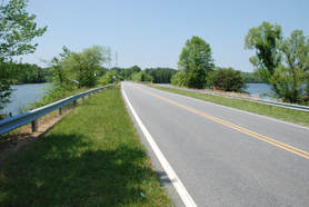
From the Plainfield Road intersection, continue south on Church Street 1.4 miles. There is water on both sides of a causeway, and the road margin on the east side is comfortably wide enough for a vehicle to get completely off the road, a good thing to do because Church Street is heavily traveled most of the day. (Make sure you do so to reduce the possibility that you’ll be ticketed by law enforcement officers.) The most popular place to park is easily identified by a patch of grassless red clay at the south end of the causeway. Use caution if it has rained recently as the parking area sometimes has muddy potholes in which a two-wheel drive vehicle could become stuck.
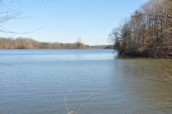
The South Church Street Overlook can be one of the better birding locations in Guilford County, particularly in late summer through mid-winter. As stated elsewhere, recent rainfall amounts and regulation of water levels by the city can greatly affect what is seen. In some years this location is nearly dry, while at other times it may be completely flooded. As a result, occasionally we have a fabulous shorebird display during migration, other times dabbling ducks are attracted to the shallows in fall and winter, and there are also times when the water is so deep that few birds are interested in it.
On the western side of the causeway is a wide, relatively shallow cove at the base of the dam for a nearby private impoundment, Lake Jeannette; the dam is just barely discernible through the leafless trees in winter. When the water is low, old stumps provide perches for Double-crested Cormorants, as well as herons and egrets in late summer. Ducks feed or loaf at the shallower west end away from the road in fall and winter. A scope will be helpful here in sorting out the waterfowl. In some years, this site may attract Redhead and Canvasback ducks. Northern Shovelers, Green- and Blue-winged Teal, Buffleheads, and Lesser Scaup are not uncommon.
To the east, the water of the inlet deepens. It is a rare birding trip here that fails to turn up one or more Belted Kingfishers. Over the deeper water, Ring-billed Gulls are common; winter brings a few Bonaparte’s and an occasional Herring Gull. In summer one may spot an Osprey fishing near its nest on one of the power line structures. This is the overlook where a "black-headed" ibis was spotted one year, later determined to be an escaped Sacred Ibis, giving local birders an exotic thrill. More commonly, White Ibises, Snowy Egrets, and Great Egrets often are seen in late summer if the water level is right. The shrubs and trees along the edge of the causeway may yield many of the common land birds of the region, especially Carolina Wrens, Song Sparrows, and in winter, White-throated Sparrows, both kinglets, and Yellow-rumped Warblers.
Looking east through binoculars one can see the Yanceyville Street causeway on Lake Townsend in the distance, the next birding destination.
There is no direct way to get to the main body of Lake Townsend if the birder is coming from Church Street, but the round-about trip usually is worth the drive. Continue south on Church Street (toward town) 2.0 miles to Lee’s Chapel Road and turn left (east). Proceed 0.9 mile to Yanceyville Street and turn left again (north). Drive north about 2 miles to the first overlook where water can be seen on both sides of the causeway.
If one comes from the city of Greensboro north on Church Street, the lake will soon be obvious. However, in this guide the directions are from Plainfield Road. Turn right (south) from the T-intersection at Plainfield Road on Church Street toward downtown, and the road will cross the western edge of Lake Townsend at two overlook points.
Stop 1. North Church Street Overlook (GPS Coordinates: N 36° 10.539’ W 079° 47.493')
Parking for this lake overlook has been reconfigured in recent years. At the intersection of Church Street and Plainfield Road will be signs directing motorist where to park. It is no longer possible to park at the trailhead of the Laurel Bluff Trail, which is just 0.2 mile south of the intersection. From the new parking area, a birder may view the lake looking east and part of the marsh by looking west. The trailhead is marked with a sign on the west side of the street. This is the east end of the Laurel Bluff Trail (3.5 miles), which will take a hiker through beautiful woodlands along the south shore of Reedy Fork Creek west to the Lake Brandt dam spillway near the Lake Brandt Marina. (Keep in mind that this isn’t a loop trail.) The trail is named for a laurel thicket through which it passes on a hill overlooking the creek, which gives the hiker the impression of being in the mountains rather than in the Piedmont. Typical woodland species of the upper Piedmont can be found along the trail, and occasionally there are ducks, as well as a few shorebirds during migration, in the shallows and mudflats of the creek.
From this parking area, one can walk a few yards to the bridge and scan both sides for waterfowl and wading birds. Looking west into the swollen Reedy Fork Creek, one sometimes can catch glimpses of ducks and wading birds if fishing boats haven’t entered the area, especially on weekdays when the marina is closed. On the other side look for Pied-billed Grebes, gulls, and a Great Blue Heron. As with all the bodies of water in the county, the water level, and the resulting degree of exposed mudflats and shoreline, affects what may be seen.
Another possibility is to walk a short way along one of the trails, especially in April and May during warbler migration. In addition to the Laurel Bluff Trail, the Peninsula Trail (1.2 miles) begins on the east side of the road. It follows the western edge of Lake Townsend and returns to Church Street farther south near the South Church Street Overlook described below. To reach the South Church Street Overlook by car, continue south as described below.
Stop 2. South Church Street Overlook (GPS Coordinates: N 36° 09.729’ W 079° 47.296’)
From the Plainfield Road intersection, continue south on Church Street 1.4 miles. There is water on both sides of a causeway, and the road margin on the east side is comfortably wide enough for a vehicle to get completely off the road, a good thing to do because Church Street is heavily traveled most of the day. (Make sure you do so to reduce the possibility that you’ll be ticketed by law enforcement officers.) The most popular place to park is easily identified by a patch of grassless red clay at the south end of the causeway. Use caution if it has rained recently as the parking area sometimes has muddy potholes in which a two-wheel drive vehicle could become stuck.
The South Church Street Overlook can be one of the better birding locations in Guilford County, particularly in late summer through mid-winter. As stated elsewhere, recent rainfall amounts and regulation of water levels by the city can greatly affect what is seen. In some years this location is nearly dry, while at other times it may be completely flooded. As a result, occasionally we have a fabulous shorebird display during migration, other times dabbling ducks are attracted to the shallows in fall and winter, and there are also times when the water is so deep that few birds are interested in it.
On the western side of the causeway is a wide, relatively shallow cove at the base of the dam for a nearby private impoundment, Lake Jeannette; the dam is just barely discernible through the leafless trees in winter. When the water is low, old stumps provide perches for Double-crested Cormorants, as well as herons and egrets in late summer. Ducks feed or loaf at the shallower west end away from the road in fall and winter. A scope will be helpful here in sorting out the waterfowl. In some years, this site may attract Redhead and Canvasback ducks. Northern Shovelers, Green- and Blue-winged Teal, Buffleheads, and Lesser Scaup are not uncommon.
To the east, the water of the inlet deepens. It is a rare birding trip here that fails to turn up one or more Belted Kingfishers. Over the deeper water, Ring-billed Gulls are common; winter brings a few Bonaparte’s and an occasional Herring Gull. In summer one may spot an Osprey fishing near its nest on one of the power line structures. This is the overlook where a "black-headed" ibis was spotted one year, later determined to be an escaped Sacred Ibis, giving local birders an exotic thrill. More commonly, White Ibises, Snowy Egrets, and Great Egrets often are seen in late summer if the water level is right. The shrubs and trees along the edge of the causeway may yield many of the common land birds of the region, especially Carolina Wrens, Song Sparrows, and in winter, White-throated Sparrows, both kinglets, and Yellow-rumped Warblers.
Looking east through binoculars one can see the Yanceyville Street causeway on Lake Townsend in the distance, the next birding destination.
There is no direct way to get to the main body of Lake Townsend if the birder is coming from Church Street, but the round-about trip usually is worth the drive. Continue south on Church Street (toward town) 2.0 miles to Lee’s Chapel Road and turn left (east). Proceed 0.9 mile to Yanceyville Street and turn left again (north). Drive north about 2 miles to the first overlook where water can be seen on both sides of the causeway.
Yanceyville and Doggett Overlooks
Stop 3. Yanceyville Street Causeway
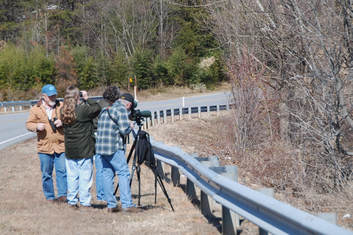
If you have time to visit only one spot on Lake Townsend, this is the place to be, especially in late fall and winter. Many of the county’s unusual sightings of water birds come from this site. The causeway is wide enough so a car can be pulled well off the road. This is important for safety because of the constant traffic.
Looking back west toward Church Street, it’s a good idea to scan the power line structures and surrounding area, especially in summer. Ospreys have nested here fairly consistently for several years. Usually, there are some gulls around, mostly Ring-billeds, but nearly every winter there are a few Bonaparte’s and an occasional Herring Gull. Double-crested Cormorants sometimes perch on the lower horizontal bars of the power line structures, as do Turkey Vultures. Look for Pied-billed Grebes in the water near the structures.
At the north end of the causeway the shallow inlet often attracts Great Egrets and an occasional Snowy Egret in late summer, and Great Blue Herons and Belted Kingfishers all year. The brush along the edge may have sparrows, wrens, and even Golden-crowned Kinglets. A Wild Turkey flew across the road at this end of the causeway during one bird club outing. However, while this species is increasing in number, it still is rarely seen around the lakes on most birding trips.
The other side of the road looking east across Lake Townsend usually is quite productive for waterfowl in winter. On sunny days, the location often is best in the afternoon and evening when the sunlight is coming from behind because of the bright reflections.
From here, one might spot Common Loons, Pied-billed Grebes (sometimes abundant), Eared Grebes (uncommon), Horned Grebes (rare but usually annual), Double-crested Cormorants, a variety of diving ducks, Hooded Mergansers, sometimes a Red-breasted Merganser, and rarely even a Common Merganser. Large rafts of American Coots often blacken the water. Gulls usually loaf in huge flocks in the middle of the lake where a scope is useful for sorting out the Herrings and Bonaparte’s from the abundant Ring-billed Gulls. Occasionally other gulls such as Glaucous are spotted. Caspian, Common, and Forster’s Terns are here in small numbers in migration.
Stop 3. Yanceyville Street Causeway
If you have time to visit only one spot on Lake Townsend, this is the place to be, especially in late fall and winter. Many of the county’s unusual sightings of water birds come from this site. The causeway is wide enough so a car can be pulled well off the road. This is important for safety because of the constant traffic.
Looking back west toward Church Street, it’s a good idea to scan the power line structures and surrounding area, especially in summer. Ospreys have nested here fairly consistently for several years. Usually, there are some gulls around, mostly Ring-billeds, but nearly every winter there are a few Bonaparte’s and an occasional Herring Gull. Double-crested Cormorants sometimes perch on the lower horizontal bars of the power line structures, as do Turkey Vultures. Look for Pied-billed Grebes in the water near the structures.
At the north end of the causeway the shallow inlet often attracts Great Egrets and an occasional Snowy Egret in late summer, and Great Blue Herons and Belted Kingfishers all year. The brush along the edge may have sparrows, wrens, and even Golden-crowned Kinglets. A Wild Turkey flew across the road at this end of the causeway during one bird club outing. However, while this species is increasing in number, it still is rarely seen around the lakes on most birding trips.
The other side of the road looking east across Lake Townsend usually is quite productive for waterfowl in winter. On sunny days, the location often is best in the afternoon and evening when the sunlight is coming from behind because of the bright reflections.
From here, one might spot Common Loons, Pied-billed Grebes (sometimes abundant), Eared Grebes (uncommon), Horned Grebes (rare but usually annual), Double-crested Cormorants, a variety of diving ducks, Hooded Mergansers, sometimes a Red-breasted Merganser, and rarely even a Common Merganser. Large rafts of American Coots often blacken the water. Gulls usually loaf in huge flocks in the middle of the lake where a scope is useful for sorting out the Herrings and Bonaparte’s from the abundant Ring-billed Gulls. Occasionally other gulls such as Glaucous are spotted. Caspian, Common, and Forster’s Terns are here in small numbers in migration.
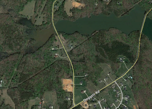
Stop 4. Yanceyville Road Marsh (GPS Coordinates: N 36° 11.641’ W 079° 45.778’)
From the center of the causeway, continue north on Yanceyville about 1.4 miles, following the curve around to the northeast past the intersection with Archergate Road. At 0.6 mile beyond Archergate, Yanceyville Rd. curves back north again at the intersection with Doggett Road (which continues straight ahead). Before exploring the Doggett overlooks, continue north on Yanceyville 0.5 mile to a marsh. Note that the shoulder is very narrow here, so use extreme caution. If something looks interesting enough to spend some time looking at it, it probably is best to continue to the end of the railing to park and then carefully walk back to a vantage point.
On the left (west) side of the road is a small marsh that can be good for migrating shorebirds if the mud flats are exposed. If it is covered with shallow water, it may attract dabbling ducks in winter and wading birds in summer.
The right side is always deeper, but sometimes there are exposed sandbars where cormorants and gulls may loaf. This spot seems to be particularly attractive to Hooded Mergansers, which sometimes are here in large rafts in winter. Watch also for diving ducks such as scaup and Ruddy Ducks. Belted Kingfishers and Great Blue Herons are common, and land birds feed around the lake edge. Across this body of water, actually a creek that has become an arm of Lake Townsend, Doggett Road can be seen in the distance.
From here, one must turn around and go back to Yanceyville Road’s intersection with Doggett Road to continue the tour. Be aware that this section of road forms a blind curve and traffic can be heavy, so continue north a few hundred yards until a suitably safe turn-around spot is found.
Stop 5. Doggett Road West Overlook (GPS Coordinates: N 36° 12.020’ W 079° 44.614’)
At the point where Yanceyville turns north, the road continues straight and becomes Doggett Road. To continue the tour of the Lake Townsend birding overlooks, go northeast 0.7 mile on Doggett Road and watch for water. (On the left is the inlet and marshy area that can be seen from Yanceyville and is described above in the entry for the Yanceyville Road Marsh.) This site often is good for Hooded Mergansers, which occasionally are seen in large rafts near the road, and for loafing Cormorants and Ring-billed Gulls.
The road edge is narrow but it is possible to get a vehicle completely off the pavement here. The safest place to park is at either end of the causeway from which birders can then walk along the road next to the metal railing to the middle of the overlook.
From here, one may look south over the center of Lake Townsend. A scope is almost a necessity for identifying the rafts of waterfowl often seen in the center of the lake. This is often the best vantage point for examining the large flocks of gulls in midwinter. Some birds do come into the mouth of the inlet and can be seen with binoculars if anglers are not present. Gulls and terns may fly over at any time.
Some birders intent on studying the ducks and gulls in the middle of the lake have been known to work their way down to the lake edge and walk along the inlet’s southern shoreline to the end of the point where they set up their scopes for a panoramic view of most of the lake. This can be a productive but muddy, wet, cold, and a difficult walk in fall and winter as there is not an established trail.
A second Doggett Road overlook is a short distance farther northeast.
Stop 6. Doggett Road East Overlook (GPS Coordinates: N 36° 11.729’ W 079° 45.190’)
For a look at the eastern end of the lake, continue northeast on Doggett Road 0.6 mile to the next place where water can be seen. As with the previous site, the road edge is quite narrow. Again, the safest place to park is at either end of the causeway. From there, birders can walk along the road next to the metal railing to a spot where they have a good view of the lake on the south side and the cove to the north.
The cove often has a nice variety of ducks, with the dabbling species such as American Black Ducks, Northern Shovelers, and Mallards usually staying at the northern marshy end when the water level isn’t too high. Although binoculars often will be sufficient, a scope may be necessary to get a good look at them.
Looking out over the lake to the southeast, one can see Bryan Park golf course straight ahead and the Lake Townsend Marina on the left. Horned and Eared Grebes sometimes may be seen from this vantage point, as well as other diving ducks. A lucky birder may spot an occasional Ruddy Duck. A Long-tailed Duck (Old Squaw) was seen here some years ago. Gulls and terns at this end tend to spend more time in the air than those loafing further down the lake, especially when fishing boats are coming and going at the marina, but there are likely to be more close flyovers, as well.
To end the tour, turn around and return south toward downtown via Yanceyville Road. Alternatively, one may continue to the last stop on the Greensboro Lakes Tour, the Lake Townsend Marina. The drive to the marina from this point will take about 20 minutes. It is a nice drive through the Browns Summit community and vicinity in rural Guilford County.
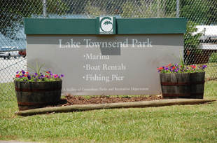
Lake Townsend Marina (Stop 7) GPS Coordinates: N 36° 10.048’ W 079° 50.208’)
The marina is located at 6332 Lake Townsend Rd., Browns Summit, NC 27214, adjacent to Bryan Park. For information about hours, rentals, fees, and events, call the marina at 336-373-3694. Currently, the marina is closed on Wednesdays and Thursdays. Hours vary by season. All Greensboro city lakes maintain normal operating hours during all holidays with the exception of Thanksgiving Day, Christmas Eve, Christmas Day and New Year's Day when the lakes are closed.
To reach the Lake Townsend Marina from the western end of the lake, follow Doggett Road 2.3 miles northeast to the intersection with NC 150. Turn right 0.3 mile and enter the community of Browns Summit. At the railroad track, turn right again on Brown Summit Road and head south. In a short time, the road name changes to Summit Avenue. At 2.9 miles you will pass through the interchange for US 29. Continue another 0.6 mile and watch on the right for a sign directing visitors to Bryan Park (a total of about 3.5 miles from Browns Summit). Turn right on Bryan Park Road, drive 0.6 mile into the park, and turn right toward the marina, which is 0.6 mile further at the end of the road.
The marina offers restrooms and snack machines. Boat rentals are available, including sailboats in summer, a relaxing way to bird the lake. There is a fee for boat rentals as well as for launching private boats, but no charge for entering the gated marina grounds. Swimming and wading are prohibited. Late afternoon is not the best birding time to bird the marina, both because of returning fishing boats, and because of the reflections on the water on sunny days.
There are several observation areas from which a group of birders can look west across the length of the lake; spotting scopes are helpful here. Non-fishing visitors may walk out on the fishing pier. Although sometimes rather crowded, the pier gives a better view of the dam and nearby north shore of the lake. One year, birders had individual Red-necked, Horned, Eared, and Pied-billed Grebes in the same binocular field of view from the fishing pier. While this may be a once-in-a-lifetime occurrence, it isn’t unusual to see up to three species of grebes at a time from this end of the lake. Common Loons should be easy to spot. Gulls and terns hang out in good numbers around the marina, although many are in the air wheeling over the boats. This is a good place to look for somewhat uncommon Herring Gulls among the Ring-billeds, and to look for the Bonaparte’s Gulls that are around nearly every year in winter. If nothing else, there are nearly always "Greater and Lesser Water Starlings" (Canada Geese and Mallards) to keep a birder company.
Return – To return to Greensboro, retrace the entry route to Summit Avenue. Local birders and others who know the area may want to turn right and find their way into the city along city streets. Others probably will find it easier to turn left on Summit and go 0.7 mile back up to the US 29 interchange. From here, one may go north to Reidsville or south to Wendover Avenue and I-85/I-40 (about 8 miles).
Finding Birds in Guilford County © 2018 Dennis Burnette